 Catalogue PIGMA
/Physical Environment
Type of resources
Available actions
Topics
Keywords
Contact for the resource
Provided by
Years
Formats
Representation types
Update frequencies
status
Scale
Resolution
-
The ODATIS Ocean Cluster (Ocean Data Information and Services) is the entry point to access all the French Ocean observation data. Its aim is to promote and facilitate the use of Ocean observations sampled by way of in situ and remote sensing measurements. ODATIS contributes to describing, quantifying and understanding the ocean as a whole — offshore and coastal.
-
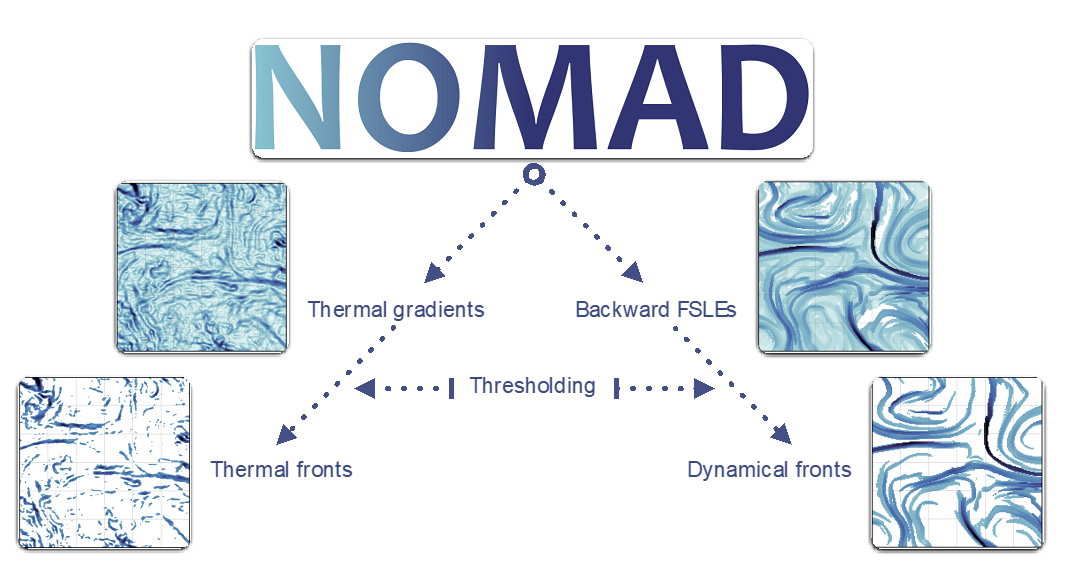
Fronts are ubiquitous discrete features of the global ocean often associated with enhanced vertical velocities, in turn boosting primary production and so forth. Fronts thus form dynamical and ephemeral ecosystems where numerous species meet across all trophic levels. Fronts are also targeted by fisheries. Capturing ocean fronts and studying their long-term variability in relation with climate change is thus key for marine resource management and spatial planning. The Mediterranean Sea and the Southwest Indian Ocean are natural laboratories to study front-marine life interactions due to their energetic flow at sub-to-mesoscales, high biodiversity (including endemic and endangered species) and numerous conservation initiatives. Based on remotely-sensed Sea Surface Temperature and Height, we compute thermal fronts (2003-2020) and attracting Lagrangian Coherent Structures (1994-2020), in both regions over several decades. We advocate for the combined use of both thermal fronts and attracting Lagrangian Coherent Structures to study front-marine life interactions. The resulting front database differs from other alternatives by its high spatio-temporal resolution, long time coverage, and relevant thresholds defined for ecological provinces.
-
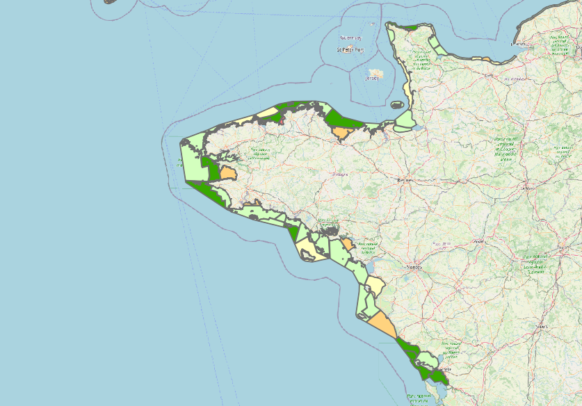
Water quality data according to the Water Framework Directive (WFD 2000/60/EC) for the surface water bodies of the Loire-Brittany and Seine-Normandy basins.
-
Marine research is truly multidisciplinary as evidenced by e.g. the EMODnet I, II, and III projects that have been running since 2009. EMODnet Geology has succeeded in bringing together harmonised offshore data including sea-floor geology, seabed substrates, rates of coastline migration, geological events and probabilities and mineral resources. The EMODnet Geology Portal aims at providing harmonised information on marine geology in Europe. It is one of several EMODnet portals with the purpose to strengthen blue growth in Europe.
-

The European Marine Observation and Data Network (EMODnet) is a long-term, marine-data initiative funded by the European Maritime and Fisheries Fund which, together with the Copernicus space programme and the Data Collection Framework for fisheries, implements the EU’s Marine Knowledge 2020 strategy. EMODnet Physics (www.emodnet-physics.eu) is one of the seven domain-specific portals of the European Marine Observation and Data Network (EMODnet). EMODnet-Physics map portal (www.emodnet-physics.eu/map) provides a single point of access to validated in situ datasets, products and their physical parameter metadata of European Seas and global oceans. More specifically, time series and datasets are made available, as recorded by fixed platforms (moorings, tide gauges, HF radars, etc.), moving platforms (ARGO, Lagrangian buoys, ferryboxes, etc.) and repeated observations (CTDs, etc.). The available themes are the temperature of the water column, the salinity of the water column, horizontal velocity of the water column, sea level and sea level trends, wave height and period, wind and atmospheric pressure, optical properties (e.g. light attenuation, back scattering, turbidity, etc.), underwater sound pressure level (acoustic pollution), river runoff, other biogeochemical data (e.g. chlorophyll, dissolved oxygen, etc.), sea-ice coverage. Acquisition of these physical parameters is largely an automated process based on a “federated” network infrastructure linking data providers and other marine data aggregating infrastructure. In particular, EMODnet Physics is strongly federated with two other European data aggregating infrastructures. One is the Copernicus Marine Environment Monitoring Service - In Situ Thematic Assembly Centre for operational data flow, while historical validated datasets are organised in collaboration with SeaDataNet and its network of National Oceanographic Data Centres. The NRT data go through a stricter quality control before NODCs validate the datasets for long-term storage and stewardship. This validation process ends when the metadata of the processed dataset are published in a CDI (Common Data Index). CMEMS-INSTAC and SDN-NODC subsets are integrated with other available sources to make the most comprehensive physical parameter data catalogues available. Thanks to international collaborative relationships to provide data access to – and preview for – coastal data in non-European areas (e.g. NOAA platforms for the US, IAPB platforms for the Arctic area, IMOS for Australia and others), EMODnet Physics catalogues are going beyond European borders to offer an even more exhaustive entry point to global-ocean physical observations.
-
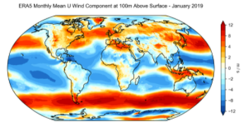
ERA5 is the fifth generation ECMWF reanalysis for the global climate and weather for the past 4 to 7 decades. Currently data is available from 1950, split into Climate Data Store entries for 1950-1978 (preliminary back extension) and from 1979 onwards (final release plus timely updates, this page). ERA5 replaces the ERA-Interim reanalysis. Reanalysis combines model data with observations from across the world into a globally complete and consistent dataset using the laws of physics. This principle, called data assimilation, is based on the method used by numerical weather prediction centres, where every so many hours (12 hours at ECMWF) a previous forecast is combined with newly available observations in an optimal way to produce a new best estimate of the state of the atmosphere, called analysis, from which an updated, improved forecast is issued. Reanalysis works in the same way, but at reduced resolution to allow for the provision of a dataset spanning back several decades. Reanalysis does not have the constraint of issuing timely forecasts, so there is more time to collect observations, and when going further back in time, to allow for the ingestion of improved versions of the original observations, which all benefit the quality of the reanalysis product. ERA5 provides hourly estimates for a large number of atmospheric, ocean-wave and land-surface quantities. An uncertainty estimate is sampled by an underlying 10-member ensemble at three-hourly intervals. Ensemble mean and spread have been pre-computed for convenience. Such uncertainty estimates are closely related to the information content of the available observing system which has evolved considerably over time. They also indicate flow-dependent sensitive areas. To facilitate many climate applications, monthly-mean averages have been pre-calculated too, though monthly means are not available for the ensemble mean and spread. ERA5 is updated daily with a latency of about 5 days (monthly means are available around the 6th of each month). In case that serious flaws are detected in this early release (called ERA5T), this data could be different from the final release 2 to 3 months later. So far this has not been the case and when this does occur users will be notified. The data set presented here is a regridded subset of the full ERA5 data set on native resolution. It is online on spinning disk, which should ensure fast and easy access. It should satisfy the requirements for most common applications. An overview of all ERA5 datasets can be found in this article. Information on access to ERA5 data on native resolution is provided in these guidelines. Data has been regridded to a regular lat-lon grid of 0.25 degrees for the reanalysis and 0.5 degrees for the uncertainty estimate (0.5 and 1 degree respectively for ocean waves). There are four main sub sets: hourly and monthly products, both on pressure levels (upper air fields) and single levels (atmospheric, ocean-wave and land surface quantities). The present entry is "ERA5 monthly mean data on single levels from 1979 to present".
-
This dataset provides a World Ocean Atlas of Argo inferred statistics. The primary data are exclusively Argo profiles. The statistics are done using the whole time range covered by the Argo data, starting in July 1997. The atlas is provided with a 0.25° resolution in the horizontal and 63 depths from 0 m to 2,000 m in the vertical. The statistics include means of Conservative Temperature (CT), Absolute Salinity, compensated density, compressiblity factor and vertical isopycnal displacement (VID); standard deviations of CT, VID and the squared Brunt Vaisala frequency; skewness and kurtosis of VID; and Eddy Available Potential Energy (EAPE). The compensated density is the product of the in-situ density times the compressibility factor. It generalizes the virtual density used in Roullet et al. (2014). The compressibility factor is defined so as to remove the dependency with pressure of the in-situ density. The compensated density is used in the computation of the VID and the EAPE.
-
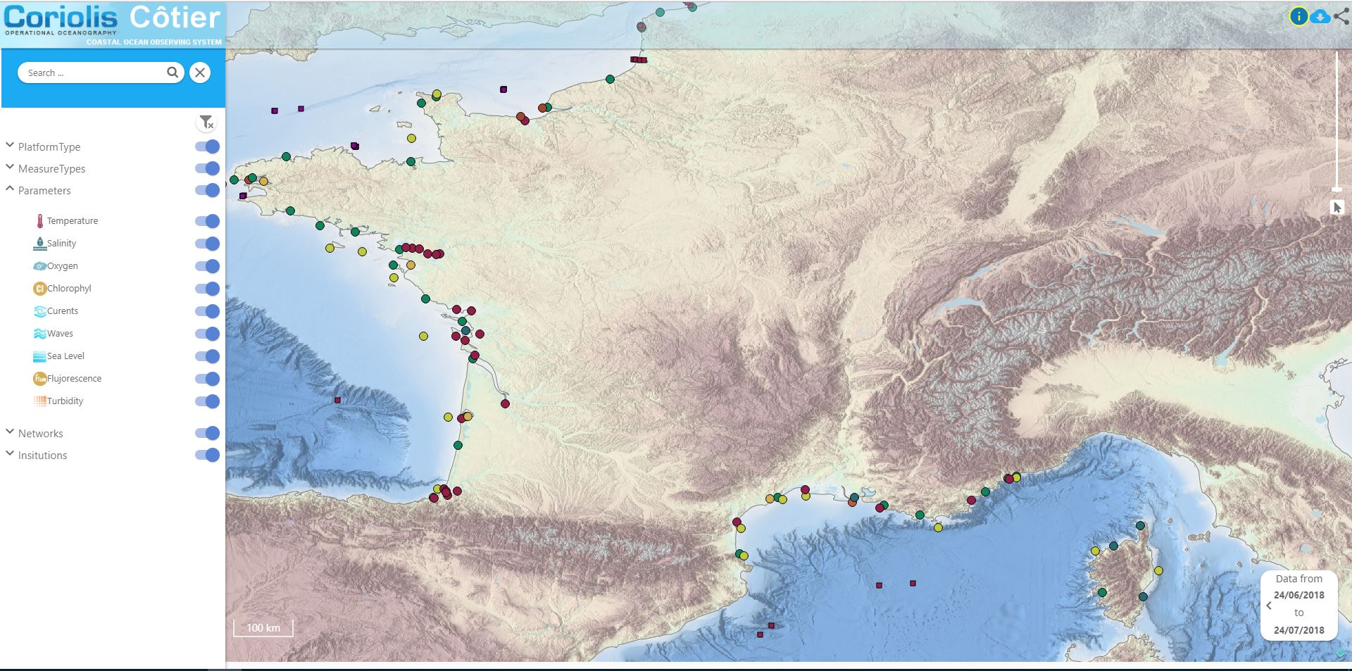
Data available in the French Coast
-

The EMODnet Bathymetry portal is operated and further developed by a European partnership. This comprises members of the SeaDataNet consortium together with organisations from marine science, the hydrographic survey community, and industry. The partners combine expertises and experiences of collecting, processing, and managing of bathymetric data together with expertises in distributed data infrastructure development and operation and providing OGC services (WMS, WFS, and WCS) for viewing and distribution. SeaDataNet is a leading infrastructure in Europe for marine & ocean data management, initiated and managed by the National Oceanographic Data Centres (NODC's). It is actively operating and further developing a Pan-European infrastructure for managing, indexing and providing access to ocean and marine data sets and data products, acquired via research cruises and other in-situ observational activities. The basis of SeaDataNet is interconnecting Data Centres into a distributed network of data resources with common standards for metadata, vocabularies, data transport formats, quality control methods and flags, and access. SeaDataNet is aiming for an extensive coverage of available data sets for the various marine environmental disciplines, such as physical oceanography, marine chemistry, biology, biodiversity, geology, geophysics and bathymetry. This is implemented by seeking active cooperation at a national scale with institutes and at a European scale with communities, that are engaged in data management for these disciplines, and by seeking opportunities for including their data centres and data collections in the SeaDataNet metadata and data provision.
-
World Ocean Atlas 2018 (WOA18) is a set of objectively analyzed (one degree grid and quarter degree grid) climatological fields of in situ temperature, salinity, dissolved oxygen, Apparent Oxygen Utilization (AOU), percent oxygen saturation, phosphate, silicate, and nitrate at standard depth levels for annual, seasonal, and monthly compositing periods for the World Ocean. Quarter degree fields are for temperature and salinity only. It also includes associated statistical fields of observed oceanographic profile data interpolated to standard depth levels on quarter degree, one degree, and five degree grids. Temperature and salinity fields are available for six decades (1955-1964, 1965-1974, 1975-1984, 1985-1994, 1995-2004, and 2005-2017) an average of all decades representing the period 1955-2017, as well as a thirty year "climate normal" period 1981-2010. Oxygen fields (as well as AOU and percent oxygen saturation) are available using all quality controlled data 1960-2017, nutrient fields using all quality controlled data from the entire sampling period 1878-2017. This accession is a product generated by the National Centers for Environmental Information's (NCEI) Ocean Climate Laboratory Team. The analyses are derived from the NCEI World Ocean Database 2018.